RESEARCH HIGHLIGHTS
RESEARCH HIGHLIGHTS
The Alaska-Yukon Region of the Circumboreal Vegetation Map
The circumboreal vegetation mapping (CBVM) project is an international collaboration among vegetation scientists to create a new vegetation map of the boreal region at a 1:7.5 million scale with a common legend and mapping protocol. The map is intended to portray potential natural vegetation, or the vegetation that would exist in the absence of human or natural disturbance, rather than existing vegetation that is commonly generated at larger scales. As a contribution to the CBVM effort, Torre Jorgenson, Alaska Ecoscience, and Del Meidinger, Meidinger Ecological Consultants Ltd., developed maps of bioclimatic zones, geographic sectors with similar floristic variability, and vegetation in boreal Alaska, Yukon, northwestern British Columbia, and a mountainous portion of southwest Northwest Territories—termed the Alaska-Yukon region. The work was supported by the U.S. Fish and Wildlife Service, Yukon Parks, the Northwest Boreal Landscape Conservation Cooperative, and the Conservation of Arctic Flora and Fauna working group of the Arctic Council.
The effort included maps of bioclimates with 12 bioclimate zones, biogeographic provinces delineating the Alaska-Yukon and Aleutian provinces, and a map of geographic sectors with six sectors that provided the basis for classification of boreal vegetation. Mapping used MODIS imagery as the basis for manual image interpretation and an integrated-terrain-unit approach, which included classifications for bioclimate, physiography, generalized geology, permafrost, disturbance, growth from, geographic sector, and vegetation. A new tree line was developed for the region. Vegetation was mapped at two hierarchical levels, including: (1) 13 formation groups differentiating zonal and azonal systems; and (2) 21 geographic variants based on bioclimatic zonation and dominant species that characterize broad longitudinal regions or biogeographic provinces. Each of the geographic variants was described by identifying the dominant and characteristic species and its climatic and landscape characteristics, as well as references that relate to the unit.

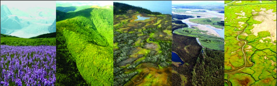
Views of main zonal forest types of the Alaska-Yukon region.

Map of boreal vegetation (level 2) in the Alaska-Yukon region.
The report and maps are available at:
Jorgenson, M. T. and D. Meidinger. 2015. The Alaska-Yukon Region of the Circumboreal Vegetation Map. Conservation of Arctic Flora and Fauna,, Akureyri, Iceland. CAFF Strategies Series Report. ISBN: 978-9935-431-48-6, 39 p.
Research Highlights
Role of Ground Ice Dynamics and Ecological Feedbacks in Recent Ice-wedge Degradation and Stabilization
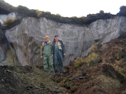
Yuri Shur and Torre Jorgenson stand in front of a large ice wedge, which is protected by only a thin layer of soil that thaws during the summer.
Ground ice is abundant in the upper permafrost throughout the Arctic and fundamentally affects terrain responses to climate warming. Ice wedges, which form near the surface and are the dominant type of massive ice in the Arctic, are particularly vulnerable to warming. Yet, processes controlling ice-wedge degradation and stabilization are poorly understood. In a recent paper published in the Journal of Geophysical Research: Earth Surface, Torre Jorgenson and colleagues from the University of Alaska Fairbanks and the U.S Geological Survey quantified ice-wedge volume and degradation rates, compared thermal regimes and ground-ice characteristics across a sequence of degradation and stabilization stages, and evaluated biophysical feedbacks controlling permafrost stability near Prudhoe Bay, Alaska. By measuring thermokarst pits on imagery from 1949 to 2012, they showed ice-wedge degradation abruptly increased in the 1990s and covered 9% of the area by 2012 (below).

In early stages, thaw settlement caused water to impound in thermokarst troughs, creating positive feedbacks that increased net radiation, soil heat flux, and soil temperatures. The disturbance stimulated plant growth and organic-matter accumulation, providing negative feedbacks that allowed ice to aggrade and heave the surface, thus reducing surface water and soil temperatures in later stages. Due to these ecological feedbacks, mean annual soil temperatures varied by 9 °C, nearly twice as large as projected regional climate warming by century’s end. This greatly complicates efforts to model and project permafrost response to climate change.

Measuring permafrost temperatures below in a recently collapsed thermokarst pit.
Jorgenson, M. T., M. Z. Kanevksiy, Y. Shur, K. Wickland, D. R. Nossov, N. G. Moskalenko, J. Koch, R. Striegl. 2015. Role of ground-ice dynamics and ecological feedbacks in recent ice-wedge degradation and stabilization. Journal of Geophysical Research – Earth Surface 120:2280-2297.
In the news

9 Feb. 2018. The Huffington Post published an article “The Arctic Refuge Still Bears Scars From Oil Exploration in the 1980s”, detailing the results of study by tundra ecologists, including Torre Jorgenson, that analyzed the potential impacts of seismic exploration in the Arctic Refuge.
article

6 May 2017. M. Torre Jorgenson was awarded the Honorary Degree of Doctor of Science from the University of Alaska Fairbanks on May 6, 2017 for his outstanding contribution to the fields of permafrost science, thereby greatly enhancing understanding of the Northern environment. From UAF News release: “Jorgenson has an international reputation as a permafrost scientist who has studied linkages in geomorphology, ecology, hydrology and soil science. His business, Alaska Ecoscience, is dedicated to studying the impacts of climate change on Alaska’s landscapes. Jorgenson’s contributions to UAF began as a camp manager at Toolik Field Station in 1977, which led him to earn a master’s degree in land resources management from UAF in 1986. His has contributed to oilfield impact assessments, land rehabilitation techniques, ecosystem and permafrost mapping, and coastal dynamics research. He has worked with many UAF graduate students and holds affiliate faculty positions with UAF’s Institute of Northern Engineering and Institute of Arctic Biology.”
article

30 June 2016. Torre Jorgenson received the Wiley-Black Permafrost and Periglacial Permafrost Journal award for excellence in permafrost research at the International Conference on Permafrost (ICOP) at Postdam, Germany on 20 June 2016. The award was given in recognition of his major influence in bridging geocryology, thermokarst research and ecology, and stimulating research in permafrost as a unifying discipline for northern scholarship. He recently coauthored with Steve Kokelj a recent synthesis on thermokarst, which was the top-cited paper in the 2014 Impact Factor Period for PPP. In accepting the award he gave a keynote address at ICOP on permafrost-ecological interactions. A video of his acceptance speech for the award is posted at Youtube,
video

8 Dec. 2015. Up to a quarter of the permafrost that lies just under the ground surface in Alaska could thaw by the end of the century, releasing long-trapped carbon that could make its way into the atmosphere and exacerbate global warming, according to a new study by Neal Pastick, as reported by Climate Central of Scienctific American. The paper, co-authored by
Torre Jorgenson and others, was published in the journal Remote Sensing of Environment. article

1 Dec. 2015. Dana Brown recently published a paper investigating how the warming climate reduces permafrost’s ability to recover following wildfires in Alaskan lowland forests. Her study, as part of her PhD research with Torre Jorgenson, was highlighted in Eos Earth & Space Science News. article

26 Nov. 2015. Alaska Daily News has an interview with Misha Kanevskiy, permafrost scientist at UAF, about his recent paper, co-authored with Torre Jorgenson in Geomorphology, on river erosion of extremely ice-rich Pleistocene permafrost (yedoma) in Northern Alaska. article

Nov. 12 2014. Alaska scientists used satellite images to look through clouds during storms and for the first time could see how far tidal flooding on the Yukon-Kuskokwim Delta extended inland. It was much farther than they imagined. In a radio new program by Daysha Eaton on APRN, Jorgenson said “It’s really extensive, it can go just about 20 miles inland during these really large storm events. So it covers a very large portion of the outer Delta”.
For APRN radio podcast podcast
For journal article in Arctic article
